Peter W. Bennett, Owner
A Full House Inspection Co. LLC
530 Prospect Avenue
Little Silver, NJ 07739
O. 732-758-9887
C. 732-245-9817
Email Me
New Jersey Infrared Commercial & Residential Roof Inspections
On-Roof Thermography of Moisture The highly sensitive FLIR T-400 infrared camera quickly identifies thermal patterns indicative of moisture problem areas in your roof. Infrared thermography is non-destructive so it is particularly well suited to find thermal anomalies created by trapped moisture under roofing membrane. The Basic Concept During the day the radiant heat of the sun heats the combined roof structure. After sunset the roof begins to shed this accumulated heat back to the atmosphere. The added thermal mass of moist insulation holds this heat longer. During this time there is a window of opportunity when a skilled thermographer will be able to image these warmer areas. The results can be quite dramatic. Therefore, tests are performs at night, using thermal imaging equipment to locate the hot thermal patterns, as called anomalies throughout your roof. These tests are non-invasive, cost efficient ways to extend the life of your roof. The areas of concern are marked on the roof and in the detailed, comprehensive PDF report. Most roofs can be extended to last an additional 12-20 years when an infrared survey program is implemented in conjuction with a roofing repair company. Waterproofing problems manifest themselves in two ways, leakage and entrained moisture contamination. Leakage is pretty simple, although the leak inside the building rarely directly relates to the exact spot on the roof, since the water flows down the slope of the roof to a spot that is not sealed and into the building at that point. Most leaks occur where the waterproofing is sealed or where there is a penetration of the roof. Since most types of roof systems absorb some amount of water, it is harder to find the exact spot of water contamination in the insulation because it may not leak into the building until it has absorbed all the water it can hold. There are three types of surveys that are used to find water in a roof: Both nuclear gauges and capacitance meters are used to take spot readings on a 5’ X 5’, 10' X 10' or 20' X 20' grid on the roof. These measurements are used to extrapolate where the water is from the readings obtained from the gauges. These surveys are very labor-intensive and therefore expensive. They are good for types of roofs that do not gain or lose much solar energy and therefore do not lend themselves to infrared. During the day, the sun radiates energy onto the roof and into the roof substrate, and then at night, the roof radiates the heat back into outer space. This is called radiational cooling. Areas of the roof that are of a higher mass (wet) retain this heat longer than that of the lower mass (dry) areas. Infrared imagers can detect this heat and "see" the warmer, higher mass areas, during the "window" of uneven heat dissipation. Infrared imagery is often a grayscale picture whose scales (or shades of gray) represent the differences in temperature and emissivity of objects in the image. As a general rule, objects in the image that are lighter in color are warmer and darker objects are cooler. No object in the images is detected via visible light wavelengths (400-700 nanometers) rather, only from infrared wavelengths in the 3000-5000 nanometers or in the 3-5 micrometers (microns) range. Lights and other relatively hot objects are very evident, but as a result of their heat, and not light emissions. When an image is taken by our infrared camera, it is often recorded on videotape and/or digitally saved to a hard drive and later converted to a digital image file with the help of a computer. The image may then be modified in a number of ways to enhance its value to the end user. The highest resolution infrared images are usually found on the digital media, while the printed pictures may be used as a convenient reference when making the building drawings or accompanying a roof report. Areas of roof moisture contamination often manifest themselves as warmer (lighter colored) areas that may be nebulous in shape and sometimes mottled in appearance, although they are commonly found in linear or puddle-like shapes. The linear shapes many times follow low areas, drainage routes, roof edges and seams. Puddle-like round or oblong shapes often form around roof penetrations such as mechanical equipment, standpipes, vents and drains. The wet areas are lighter in color because the latent heat (from daylight sunshine) in the trapped water mass is greater than in the dry, functioning insulation or roof substrate. After sunset when the roof structure cools down, wet areas of roof insulation and other materials continue to radiate heat, allowing our sensitive infrared cameras to detect the sources of heat and record them for later analysis.
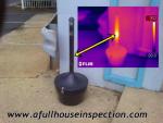
On-Roof Infrared We create detailed, high-quality and easy to Roof professionals can then use the information to verify the wet areas and write specifications to repair the roof. Why Aerial Infrared Performing infrared roof moisture surveys while standing on the roof is not the best method because imagery from a walk-on survey is not as useful as aerial imagery. The same laws of physics apply to both aerial IR and on-roof IR. A dry roof, low winds and no rain are needed on the night of the survey. However, the "window" when the roof is radiating heat differently from wet and dry areas is longer with aerial infrared because slight nuances of temperatures over large areas are recognizable. A high angle of view and high resolution are needed to produce usable imagery. We use large-format infrared cameras, which have at least 512 x 512 staring array detectors (262,144 pixels). From an altitude of 1,200 – 1,500 feet above the roof with over a quarter of a million pixels, the ground resolution element is about six inches square. Visual photographs are taken earlier in the day or the next day. Both visual and infrared images are used to do the analysis by overlaying the AutoCAD drawing of the roof ‘over’ the digitized photographs and thermographs. The drawings are created indicating areas of suspected moisture contamination. The result is a report where visual, infrared and AutoCAD components (printed and video) are well matched and lined-up. Fixed-wing aerial infrared imaging provides many advantages over on-roof infrared imaging: Aerial IR allows the building owner to buy only the report he needs at that time. Further processing can be done on roof areas of specific concern. The report components are as follows in order by cost: The biggest advantage of aerial infrared is on roofs that are the most difficult to image from any distance or angle. Roofs that, for instance, have a lot of ballast, are covered with reflective coatings or for whatever reason are impossible to image from the roof. With high-resolution, plan view aerial imagery, slight nuances of temperature can be seen from far enough away to actually see the pattern of heat and make a determination of where the problems are. The aerial infrared is a provided service of Roof Scan IR, United Infrared (AITscan) has performed qualitative infrared thermographic surveys of roof moisture on thousands of buildings. We brought together all the components that truly make us the state-of-the-art in the field of infrared thermography. Our deliverable product is the best on the market today. We use high-resolution infrared imagers, digital recording equipment, techniques that have been refined over the years and the attitude that we are going to obtain the best imagery possible and produce a professional report in a timely manner. Visible Photograph does not show any signs of leaks Thermograph clearly shows thermal patterns of trapped moisture under the membrane (light gray areas) CAD Drawing provides road map to help you and your roofer coordinate efforts. ROOF ASSET MANAGEMENT Example of mosaic visible image of a low-sloped roof Example of mosaic thermal image of a low-sloped roof Example of mosaic visible image of a low-sloped roof with CAD drawing overlay Example of mosaic thermal image of a low-sloped roof with CAD drawing overlay If you are not familiar with this widely used and accepted technology, please call me to discuss your questions, comments or concerns.
Roof Maintenance in General
Roof Infrared Basics

Understanding Infrared Roof Imagery


understand reports documenting roof moisture. 

High-resolution images capture large areas at once, making report writing easier and less expensive to produce.
Imagery Examples


Why cover a wet roof?


Peter W. Bennett, Owner
www.AFullHouseInspection.com
Residential & Commercial Building Inspections
Infrared Thermal Imaging Services
(Energy Loss, Plumbing, Moisture & Roof Leaks, Electrical Systems, Structural Defects)
530 Prospect Avenue Little Silver, NJ 07739
Office 732-758-9887 Cell 732-245-9817
NJ Home Inspector Lic#GI371
NJ DEP Radon MET11140
Certified Infrared Thermographer No.7406
Certified Energy Inspector No. 1364
Certified ASHI Member #205748
Certified Member of INACHI